Another scientific study of our APRI members from the University of Graz and Innsbruck was recently published on the International Journal of Climatology. The collaboration between Tiago Silva, Manuela Lehner and Elisabeth Schlosser produced a thorough analysis of 25 years of temperature and humidity inversions features at Neumayer Station, Antarctica.
What is an atmospheric inversion?
Temperature and humidity do not always decrease with altitude. For example, you certainly have noticed that particularly in winter the sky looks often overcast from the window, but when you go for a hike or for a ski tour, you find just a few hundreds of meters above the surface that the sky over certain Alpine peaks is cloudless with a vast sea of clouds covering the mountain valley. Such phenomenon happens under the presence of a temperature and humidity inversion. In this specific case, the air over the white-covered mountains is cooled down by the snow, it moves downhill along the steep slopes and settles in the valley forming the so-called cold air pool. This heavy and often dry air remains stagnant until the arrival of either sun rays or winds strong enough to wipe out the inversion.
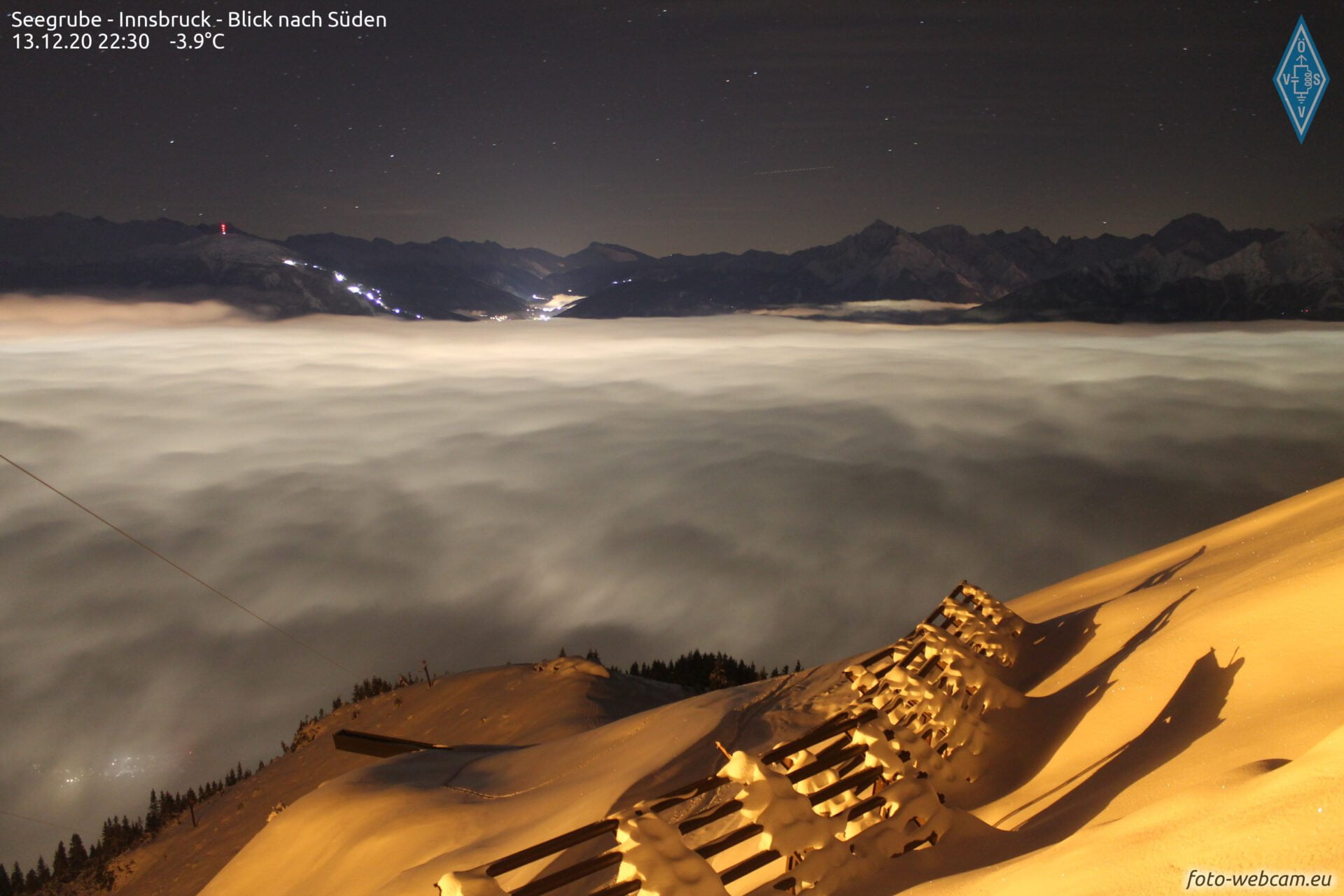
Figure 1: Typical low cloud layer associated with a temperature inversion in a mountain region. (from foto-webcam.eu)
Inversions exist almost permanently all year-round over the polar regions. Especially under the influence of high-pressure systems, the snow-covered surface and the prolonged absence of sunlight promotes the formation of temperature inversions by cooling the overlying air.
There are several features that generally characterize inversions: its strength, depth, and elevation. The inversion strength accounts for the temperature (or humidity) increase from the bottom (low temperature) to the top (high temperature) of the inversion; the depth details the altitude between the bottom and the top of the inversion; and finally, elevation, which indicates the altitude at which the inversion bottom lays. The inversion example described above belongs to the group of surface-based inversions because its inversion bottom is very close to the surface. However, inversions happen in a wide range of altitudes with multiple formation mechanisms.
How can we measure an atmospheric inversion?
Inversion features can be calculated with the support of atmospheric observations (e.g., weather balloons a.k.a. radiosondes). Radiosondes are constituted by a small electronic device attached to a balloon filled with helium. The electronic device comprises several sensors to measure air pressure, air temperature, humidity, wind speed and direction as well as pollutant concentrations in the atmosphere. Radiosondes are not only useful to study atmospheric inversions but also, for example, to support daily weather forecast worldwide.

Figure 2: Radiosonde launch at Dome Fuji Station in Antarctica by Dr. Konosuke Sugiura. (Credit: Taichi Ito)
Where is Neumayer Station?
The study performed by our APRI scientists is based on 25 years of radiosonde data collected at Neumayer Station II and III (in Figure 3 marked by a dark circle). Neumayer Station is a German Antarctic research station constructed in 1981 on the Ekström Ice Shelf in coastal Dronning Maud Land (Queen Maud), East Antarctica. The coastal Dronning Maud Land faces the Atlantic Ocean, and the nearest piece of land is the southern tip of Africa. The earliest base lasted 11 years and was substituted by Neumayer II in 1992. In 2009, Neumayer II was then replaced by the modern Neumayer III (hereafter called “Neumayer”). At Neumayer, the sun stays permanently above the horizon from mid-November to mid-January (polar day) and permanently below the horizon from mid-May to mid-July (polar night).
The Ekström Ice Shelf is one of the smaller ice shelves in Antarctica, stretching south for approximately 120 km and is bordered by ridges of ca. 500 m elevation to the east and west. The surrounding ocean is covered by sea ice for the largest part of the year.

Figure 3: The Dronning Maud (in homage to the Norwegian Queen Maud of Wales Land) and the typical flight routes within the Dronning Maud Land air network. Neumayer Station is highlighted by the dark circle. (Source: König-Langlo and Loose (2007))
Why studying atmospheric inversions in Antarctica?
A special application of inversion studies is the paleoclimatic interpretation of ice and snow records in the form of cylindrical cores. As snow falls, it leaves the imprint of the atmospheric composition of that exact moment. Over consecutive snow events, the snow gradually compresses in snow layers. As time passes, the climate history of that particular location is year-by-year recorded and accessible via ice cores. The longest ice core samples are retrieved from pristine polar sites such as Greenland and Antarctica.
Ice cores, similar to tree rings, provide clues about previous atmospheric compositions and could reveal how warm or cold previous climates may have been in the past. The derivation of paleotemperatures from previous atmospheric composition is based on the relationship between the “fingerprint” left by the former precipitation event and the associated condensation temperature and not by the surface temperature. As strong inversions prevail at most deep drilling locations, the temperature at the top of the inversion is often assumed to be the condensation temperature.

Figure 4: Scientist taking ice core samples. (Source: NSIDC courtesy Ted Scambos and Rob Bauer)
Why is the current study important?
For the first time, the APRI scientists made a classification to separate inversions depending on the weather observed at the Antarctic station. Given the 25 years of data their results reveal differences in seasonality and inversion features (strength and depth) as dependent on the weather condition and altitude of occurrence. In this way, they were able to distinguish inversions formed by surface cooling and to mainly concentrate on inversions related to precipitation events. In contrast to the calm wind conditions described above on the formation of a temperature inversion in an Alpine valley, they emphasize the strong and humid winds transporting heat and moisture from the ocean towards coastal Antarctica. The 25-year climatology reported in their study serves now as a first step to better understand Antarctic inversion features and to challenge oversimplistic assumptions in paleoclimate studies. The current work developed by the APRI investigators goes beyond the published findings and could in the future be adapted to other Antarctic regions.
Why do we care about paleoclimate?
Life exists on the planet Earth for hundreds of millions of years. However, the planet Earth have witnessed several mass extinctions. Life, and the climate, have changed since its beginning. In addition to natural climate changes (e.g., volcanic eruptions, solar cycles, Earth axis cycles), the practices used to make Us the most technologically developed specie caused irrefutable changes in the Earth system. With the support of advanced technological devices, paleoclimate studies help us understand past climates and to assess how the Earth’s past atmosphere may have responded to changes in atmospheric temperature as well as atmospheric composition. Nevertheless, there are still many stories hidden under ice to tell.
Media information
Written by Tiago Manuel Ferreira da Silva
Edited and layout by the APRI-media team
Contact: use our contact form.
Header photo: © Elisabeth Schlosser
About the scientific author
Tiago Manuel Ferreira da Silva, University of Graz, Austria
To the scientific publication