Austrian Polar Scientists provide a novel pan-arctic settlements map to COP26
The Austrian Polar Research Institute member Annett Bartsch, managing director of b.geos, has more than twenty years experiences in satellite image processing and focuses on research questions around permafrost and how it is impacted by the warming climate. Her recent project in collaboration with former APRI director Peter Schweitzer from the Department of Social and Cultural Anthropology at University of Vienna is part of the Nunataryuk and CHARTER projects of the European Union’s Horizon 2020 Research and Innovation Program. The results are published in the Environmental Research Letters and were able to deliver first-time high-resolution data which allowed to map the human impact on the circumpolar Arctic coasts within a 100 km range covering 6.2 Mio km2. The European Space Agency has published an Arctic human impact map based on her data to demonstrate the accelerating climatic changes and their impact on new infrastructure development across the Arctic. It was presented at COP26 by Hugues Lantuit, Alfred Wegener Institute (AWI), at the Permafrost Day at COP26 Cryosphere Pavilion.

Updated record of settlements along the Arctic coastline and permafrost extent (Obu et al. 2021). Source: Bartsch et al. 2021
Background
Global warming is driving wide spread degradation of the Earth’s cryosphere and warming in the Arctic is more pronounced than the global average (IPCC 2021). Several million people are living in permafrost regions in the Arctic. Ground temperatures are increasing and permafrost degradation is occurring in many regions. Arctic coastal communities are seen especially vulnerable to climate change due to the combined effects of sea ice loss and permafrost thaw. The latter is considered a thread to the local environment and settlements. It affects the vulnerability of local and indigenous populations. The impact with respect to the economic value of ecosystem services, minerals and oil exploitation needs to be considered for a sustainable development of these regions.
AI analysis of Satellite data
Satellite data can be used to improve the detection of infrastructure indicating human activities. The team of Bartsch used Satellite Sentinel-1/2 datasets and applied artificial intelligence (AI) algorithms to identify transport infrastructure like roads and railway, buildings, and other impacted areas (Arctic Coastal Human Impact, SACHI). The study of Bartsch could provide a quantified change of recent human impact in the panarctic coastal zone since 2000, and identified infrastructure potentially impacted by recent climate change through combination with permafrost time series.

Animation showing permafrost change 1997 to 2019 (Permafrost CCI project, Obu est al. 2021) issued for COP26.
Credit: ESA; ESA/Permafrost climate change initiative/NSIDC Sea Ice Index
“The results suggest that the detectable human-impacted area in the Arctic coastal region increased by 15% since 2000.“
Annett Bartsch
The identification of infrastructure and population centres across the Arctic provides a step forward for human impact monitoring in Arctic environments. The combination with satellite derived vegetation index (NDVI) trends allows for identification of recently built infrastructure. The majority can be attributed to the oil/gas industry highlighting continued industrial development.
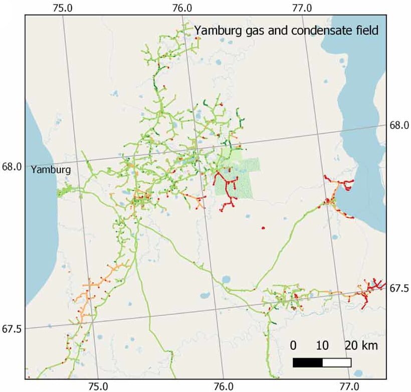
Vegetation Index (NDVI) changes from 2000-2018 within human impacted areas as mapped with Sentinel-1 and -2 for the Yamburg gas and condensate field in Western Siberia. Red indicates new human impacts after 2000. (modified from Bartsch et al. 2021)
“With 10 meters resolution, mapping becomes feasible, though there are still many features (human-made or otherwise) you can’t detect even with that resolution.“
Annett Bartsch
Identified human impacts
Most of the identified human impacts occurred in Russia, but also some in Canada and US.
- 31% and 5% of impacted area associated predominantly with oil/gas and mining industry respectively has appeared after 2000.
- About 50% of the impacted area will be shifting to above 0°C ground temperature at two meter depth by 2050 if current permafrost warming trends continue at the pace of the last two decades.
These results highlight the critical importance to better understand how much and where Arctic infrastructure may become threatened by permafrost thaw. Positive ground temperature trends during the last two decades were observed for the vast majority of identified infrastructure objects. Although the goals for COP-26 were high to finally create binding targets for all nations to keep the earth’s warming below 1,5°C, its results remained vague and disputed due to the diverse interests of the world’s nations. Still, hope remains that all nations recognize the importance of effective measures for a decarbonization of human society with an agreed short-term implementation.

Identification of soil properties in permafrost regions is important to complement Satellited-based results (© Bartsch)
Media information
Written by Christoph Ruhsam, APRI Media Officer.
Contact: use our contact form.
About the scientific author
Annett Bartsch, b.geos, Austria
Access to the original paper.
Read about the Nunataryuk project and the ESA press release.